Navigation for Newbies: Master Colorado Trails with Just Your Phone
by Melody Monberg, Hike for Life Operations Manager
When I first moved to Colorado, I assumed I had to become “outdoorsy” right away—complete with flannel shirt, hiking boots, a backpack full of granola bars.
But I quickly realized I didn’t know the first thing about hiking Colorado trails. What even is a trailhead? How do you know where to start? Words like elevation gain and mileage sounded mysterious and intimidating. I knew there was so much to explore here, but I had no idea how to begin.
Maybe you’ve felt that way, too.
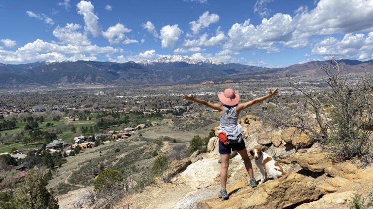
If so, Garden of the Gods is the perfect landing spot for first-time Colorado hikers. This iconic, free park in Colorado Springs has well-marked, easy-to-follow trails—and it’s a great place to build your confidence with a hiking app. Navigation is one of the Five Fundamentals of Hiking, a set of core skills we teach at Hike for Life, and Garden of the Gods is an ideal place to practice. The outer trails are especially helpful as a training ground to get familiar with using map apps while still staying close to a visitor-friendly, accessible hub.
Trail Terms 101 (a.k.a. What Are These People Even Talking About?)
Let’s decode the basics so you can hit the trail like a pro (or at least like someone who won’t get totally lost):
● Trailhead: Fancy word for “where the hike starts.” Sometimes it’s a big paved parking lot with signs and maps (like at Garden of the Gods), other times it’s just a wooden post next to a dirt path. Either way, this is your launch pad.
● Elevation: Basically, how high up you are—and how much higher you’ll need to go. Elevation gain is the total climbing involved. Think of it like the number of flights of stairs you’d climb if the mountain were a building. More gain = more huffing and puffing, especially in Colorado’s thin air.
● Mileage: No mystery here. This is how long your hike is, from start to finish. (Just don’t forget that a 2-mile out-and-back is really 1 mile each way—ask me how I learned that one.)
● Route Types:
○ Out & Back: You hike to a cool spot, then turn around and return the same way. Simple and easy to follow.
○ Loop: A circular route that brings you back to your starting point without retracing your steps.
○ Lollipop: Picture a lollipop—straight stick, round top. You hike a straight trail (the “stick”), loop around (the “candy”), and then return the way you came. It’s a combo of out-and-back and loop. Great if you want variety without getting too far off the main path.
A Few Tips for Getting Started
● Battery Drain is Real: Map apps use a lot of power. Bring a portable charger or backup battery if you’re using your phone as your main guide.
● Download Your Map in Advance: If you pay for AllTrails+ (formerly Pro), you can download maps for offline use—super handy in areas with spotty reception.
● Print a Map Too: Old-school is still cool. Print out your map and take note of the trail’s turns and mile markers. Practicing this helps you develop a sense of time and distance—key for future hiking adventures.
Put Your Phone to Work (Garden of the Gods Makes Perfect Practice)
While you’re exploring Garden of the Gods, it’s the perfect place to practice using your phone as a trail guide. The park is full of well-marked paths, good cell service, and manageable terrain—ideal for building your confidence with navigation apps. Download the free AllTrails app and search for ‘Garden of the Gods.’ You’ll find several hikes labeled by difficulty: easy, moderate, or hard. These ratings come from fellow hikers’ experiences, so they’re usually spot-on.
Pick a trail that catches your eye—like the Perkins Central Garden Trail (easy and paved) or the Susan G. Bretag Trail (a quieter, gravel and dirt path with unique views).
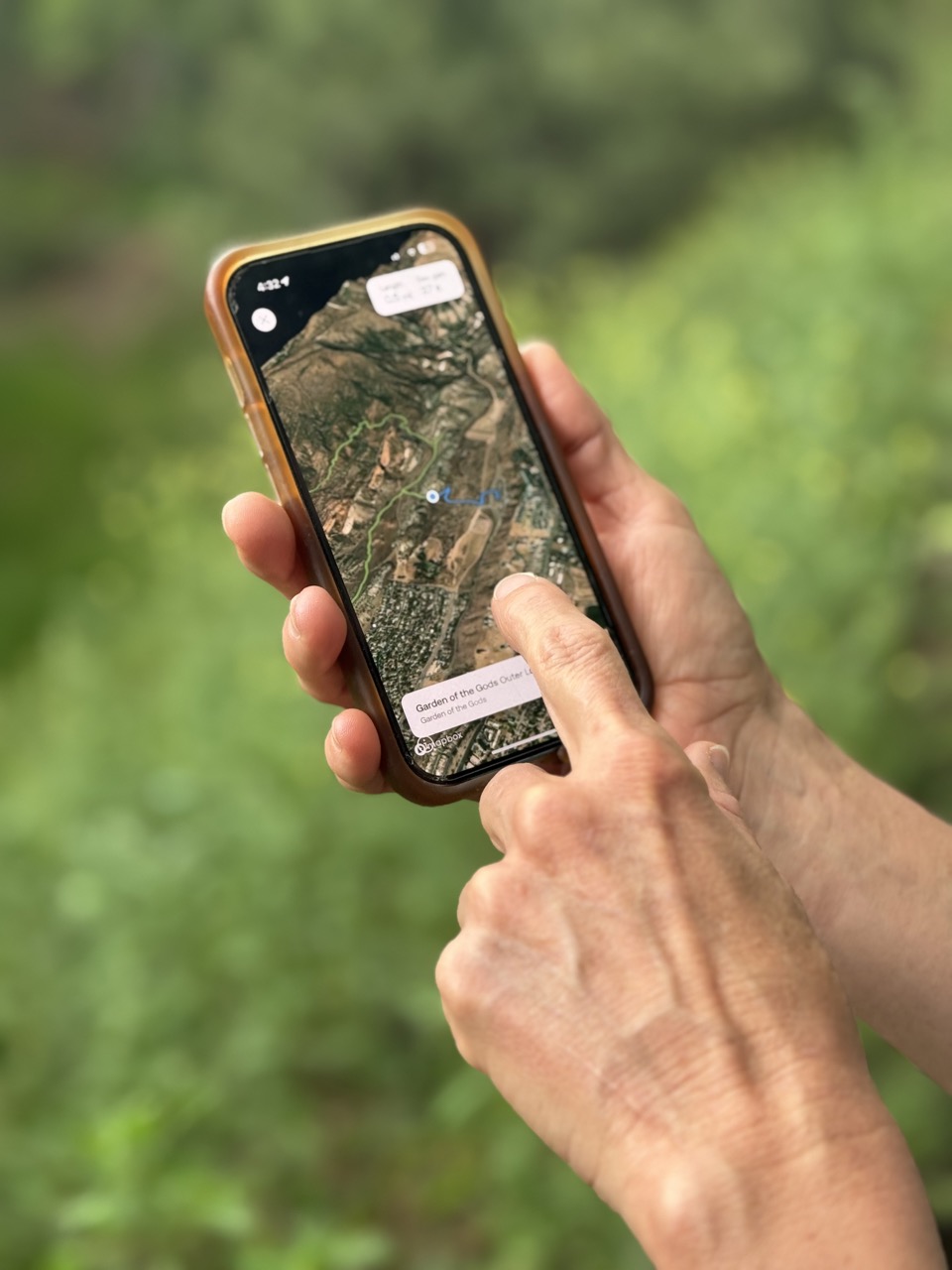
Once you select a trail, AllTrails shows you a map with the route clearly outlined—and your current location pops up as a little blue dot. As you walk, watch the dot move in real time, showing exactly where you are. Pause now and then to zoom out, see where the trail loops or forks, and practice reading your location on the map.
Don’t worry if it feels awkward at first—that’s exactly why Garden of the Gods is such a great place to practice. You’ll get a feel for how long it takes you to walk a mile, learn to spot trail turns, and get comfortable checking your location at tricky intersections.
Even with apps, there will be moments when the map feels confusing. Maybe the trail splits, the GPS blips, or you’re just unsure if you’re on the right path. When that happens:
● Stop and look around—check for trail signs, cairns (those little piles of rocks), or landmarks.
● Zoom out on your map and see if you can match what’s around you with features on the screen, like a creek or a distinctive rock.
● Trust your feet and stick to the main trail.
● And always remember: when in doubt, it’s smarter to turn back than to risk getting lost—and hey, more time for trail snacks!
Build Your Navigation Confidence
Ready to take your new skills up a notch? Try this fun mini challenge next time you’re at Garden of the Gods (or any nearby park):
1. Pick two nearby trails—like the Central Garden Trail and the Susan G. Bretag Trail.
2. Start hiking one trail, paying attention to your blue dot and how it moves on the map.
3. At a fork or junction, practice switching your app to follow the other trail instead.
4. Notice how your location updates and how the map shows your progress.
This little navigation workout is like training wheels for your hiking adventures—helping you get comfy switching up your route on the fly. Trust me, once you’ve got this down, Colorado’s trails feel a whole lot more like your personal playground.
Before you know it, you’ll be ready to tackle new paths with confidence—and the whole wide world of Colorado hiking will be yours to explore.
Want to Explore More Nearby Trails?
If you arrive at Garden of the Gods and the parking lot is full (it happens!), don’t worry—there are plenty of other beautiful parks just a short drive away. While Garden of the Gods is a favorite of mine, these two nearby spots offer equally stunning scenery and great trails to practice your new navigation skills:
● Red Rock Open Space: Just across Highway 24, this open space features quiet trails with stunning views back toward Garden of the Gods. Try the Mesa Trail Loop for a beginner-friendly option.
● North Cheyenne Cañon: Near the Broadmoor Hotel, this area has more challenging hikes and some incredible views. Try Seven Bridges Trail for a fun mix of forest, bridges, and gentle climbing.
Other Hiking Apps to Try
● COTREX (Colorado Trail Explorer): Free and backed by the state, this app offers excellent local trail info and maps.
● Gaia GPS: Great for detailed topo maps and off-the-grid navigation.
● CalTopo: Advanced mapping for backcountry trips, showing public and private land boundaries.
For me, learning to use a map app took patience, but it was worth every fumbled attempt. Once you know where you’re going – and how to get back – Colorado’s trails transform from intimidating unknowns into your personal adventure network.
One final tip: Always tell someone where you’re hiking and when you plan to return. Want more beginner-friendly tips and guided outings? Visit Hike for Life to explore hikes and our full breakdown of the Five Fundamentals of Hiking.
Happy hiking—and maybe I’ll see you out there soon!